Inertial Navigation System (INS), also called INS, is a navigation device that provides roll, pitch, heading, position, and velocity. This sophisticated technology determines an object’s position, orientation, and velocity without relying on external references.
This self-contained navigation solution is crucial in various applications, ranging from aerospace and defense to robotics and autonomous vehicles.
What is an Inertial Navigation System (INS)?
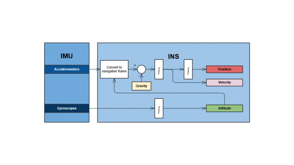
Inertial Navigation System (INS) is a navigation technology that uses motion sensors to calculate an object’s position, velocity, and orientation based on its initial starting point. Unlike satellite-based systems like GPS, INS does not rely on external signals but instead uses internal sensors to track changes in motion over time. This makes INS particularly useful in environments where external signals are unavailable or unreliable.
Key Features
1 – Self-Contained: Operates independently of external navigation aids, making it suitable for applications in areas with poor or no satellite visibility.
2 – High Accuracy: Provides precise measurements of position and orientation by integrating data from motion sensors.
3 – Real-Time Data: Offers continuous updates on an object’s position and orientation, crucial for dynamic and fast-paced environments.
Technologies Behind INS
Inertial Navigation Systems rely on several core technologies to deliver accurate navigation data. These technologies include advanced sensors and computational algorithms that work together to track an object’s movement. Here’s a closer look at the key technologies used in INS:
1- Gyroscopes
Gyroscopes are essential components of an INS, used to measure angular velocity or rotation rates around different axes.
- Ring Laser Gyroscopes (RLGs): Utilize laser beams to measure rotation with high precision. RLGs are known for their low drift and long-term stability.
Fiber Optic Gyroscopes (FOGs): Use the interference of light traveling through optical fibers to measure rotational motion. FOGs offer exceptional accuracy and minimal bias instability.
2 – Accelerometers
Accelerometers measure acceleration along different axes and work with gyroscopes to determine changes in velocity and orientation.
- Micro-Electro-Mechanical Systems (MEMS) accelerometers are compact and cost-effective, providing reliable performance for many INS applications.
- Offer enhanced accuracy and stability, crucial for high-end INS applications where precision is critical.
3 – Computational Algorithms
Computational Algorithms process data from gyroscopes and accelerometers to calculate position, velocity, and orientation.
- Integration Algorithms: Integrate acceleration data over time to determine velocity and position. These algorithms account for initial conditions and continuously update the navigation data.
- Error Correction Algorithms: Address and correct biases and drifts in sensor measurements to improve accuracy and reliability.
Applications of INS
Inertial Navigation Systems are used across various industries and applications where accurate navigation and positioning are required. Here are some notable examples:
In the aerospace industry, INS provides precise data for aircraft navigation, particularly during flight phases where GPS signals may be weak or unavailable. It also assists in spacecraft navigation and control, including satellite positioning and interplanetary missions.
In defense and military applications, INS ensures accurate targeting and guidance for missiles, which is crucial for effective and reliable strike capabilities. It also enhances the navigation and operational effectiveness of military ground vehicles, including tanks and armored personnel carriers.
In autonomous vehicles, INS supplies critical navigation data for self-driving cars, helping them maintain accurate positioning and orientation even in environments with limited GPS availability. It also supports drones in achieving precise flight control and navigation, ensuring stable operation in various conditions.
In robotics, INS aids in navigating complex environments, from industrial automation to exploration tasks, by providing accurate position and orientation data. It also enables surveillance robots to maintain precise positioning and movement control during monitoring and inspection tasks.
Inertial Navigation Systems (INS) play a crucial role in modern navigation and positioning technologies. They provide precise, reliable data without relying on external references.
Using advanced technologies like gyroscopes, accelerometers, and computational algorithms, INS continuously updates position, velocity, and orientation.
INS serves various industries, including aerospace, defense, autonomous vehicles, and robotics. Its versatility is evident in both high-stakes and everyday scenarios.
As technology progresses, the capabilities and applications of INS will continue to expand. This growth will meet the evolving demands for navigation and positioning.
