Enhancing mobile mapping solutions with SBG Systems
With our Navsight Apogee solution, supporter by Qinertia PPK software, VSK Global‘s could deliver to end users the whole package in their mobile mapping system, going from data collection to design and customization, thus focusing on digital-twin, flood simulation, smart farming and net zero.
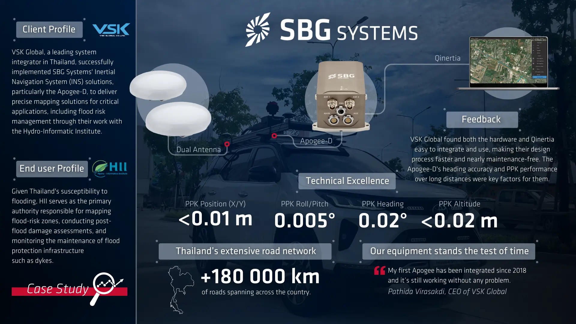
“My first Apogee is integrated since 2018 and it still working without any problem.” | Pathida Virasakdi, CEO of VSK Global.
VSK Global’s partnership with SBG Systems has proven to be strategic, delivering high performance mobile surveying and exceptional value to their clients.
VSK Global: Thailand’s leading system integrator
Our client, VSK Global Company Limited stands out as a leading system integrator in Thailand. Specializing in GNSS, SLAM, MMS, USV, and UAV technologies, they have established themselves as a key player in a diverse range of industries, including hydrology, agriculture, and infrastructure development.
As a reseller of SBG’s solutions, VSK Global possess a reputation for delivering a comprehensive mobile mapping and bathymetric survey solution to their clients.
Delivering value to end users
The end users of VSK Global’s solutions, including the Hydro-Informatic Institute and Bedrock Analytics, have benefited greatly from the reliability and ease of use of SBG Systems’ products.
A prime example of VSK’s impact can be seen through their work with the Hydro-Informatic Institute (HII), a key governmental agency in Thailand. HII’s critical mission involves preventing and managing water-related risks across the country.
Given Thailand’s susceptibility to flooding, HII serves as the primary authority responsible for mapping flood-risk zones, conducting post-flood damage assessments, and monitoring the maintenance of flood protection infrastructure such as dykes.
This partnership demonstrates how VSK Global’s implementation of our inertial navigation solutions directly contributes to essential public safety and infrastructure management initiatives.
How we faced this mobile mapping challenge
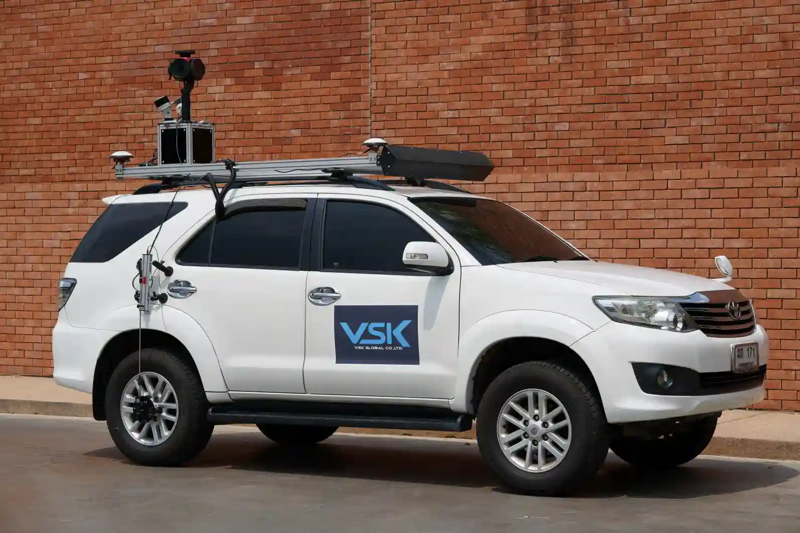
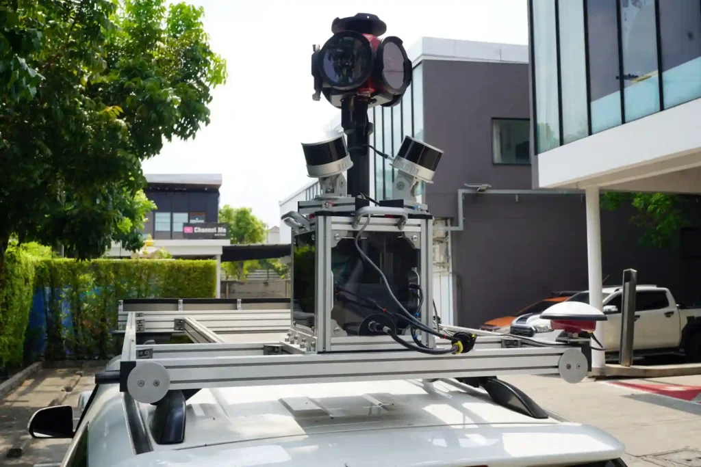
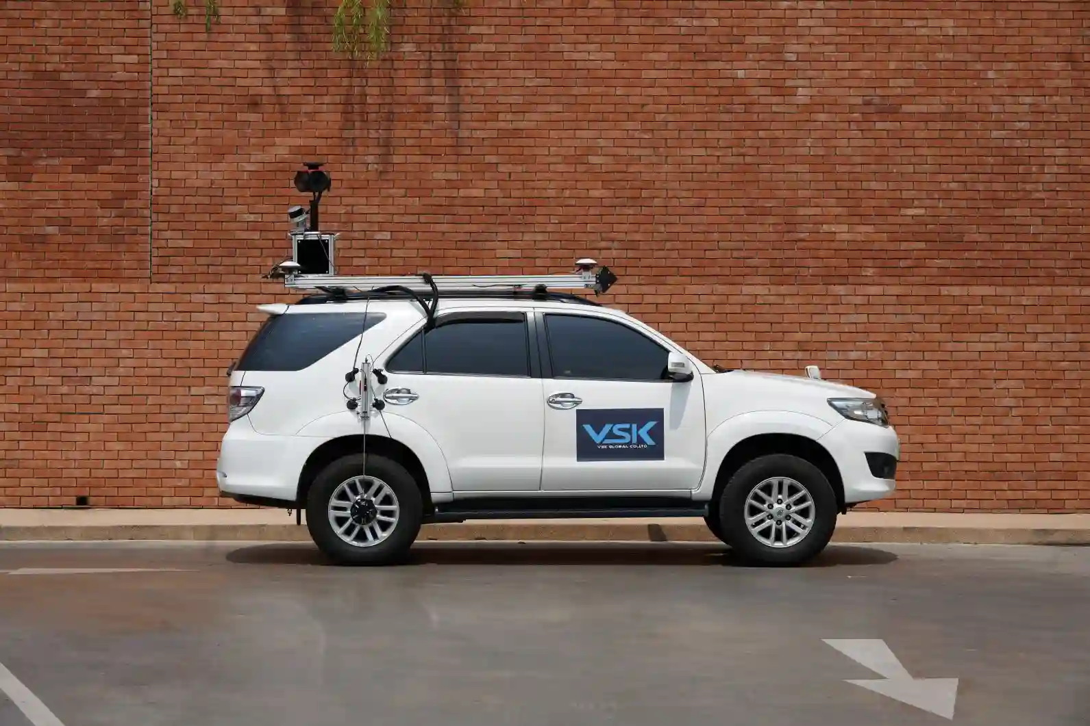
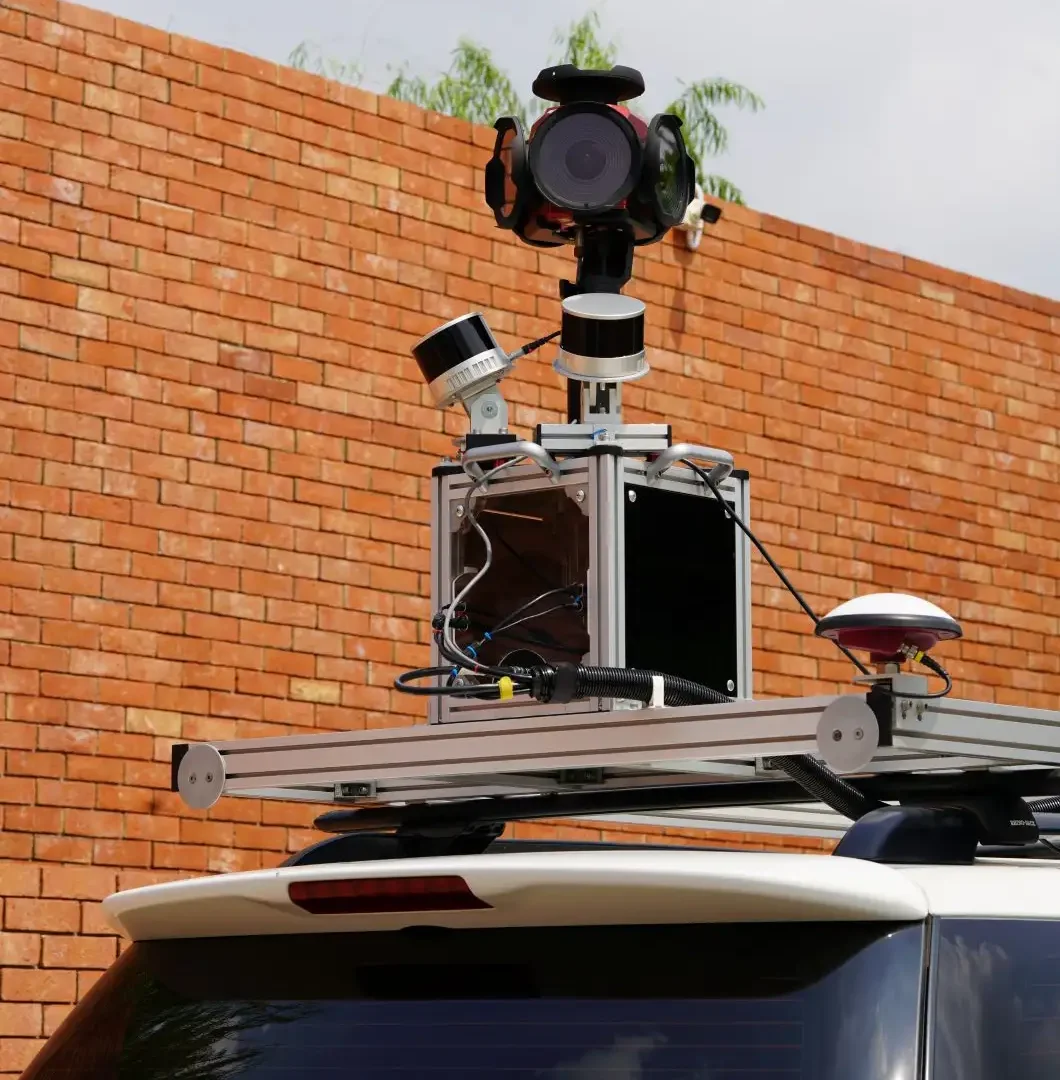
VSK Global faced a significant challenge: they needed an Inertial Navigation System (INS) that could operate flawlessly in challenging environments. These environments included areas with high-rise buildings, under bridges, and in long tunnels, which are typical for applications like mobile mapping systems and bathymetric surveys. This is where we came into the picture.
Seamless integration and exceptional support
Our collaboration with VSK Global began with a strong foundation of education and support. We took the time to educate VSK Global’s team and provided valuable suggestions for system design and integration.
This initial engagement set the stage for a successful partnership where our products were seamlessly integrated into VSK Global’s mobile mapping system, which include a laser scanner and a 360-camera.
Throughout the integration phase, VSK Global received all the necessary assistance and found the support portal to be extremely helpful. According to VSK, the technical support provided by SBG Systems was prompt and efficient. They quickly confirmed that our Apogee-D and Horizon FOG-based IMU met their expectations.
During their research phase when choosing which company would provide the best solution, they discovered that Apogee-D’s performance surpassed other brands—a key factor in their decision to partner with us.
“I try to get more information about the problem or question that I might have from the ‘Knowledge Base’. Then if those explanation from ‘Knowledge Base’ are uncleared for me then I will contact technical staff which most of the time solved all my problem.” Concludes VSK Global’s CEO, Pathida Virasakdi.
VSK’s feedback and the power of our products
- VSK Global praised the hardware for being easy to integrate and the software, Qinertia, for being well-documented and intuitive. This combination made their design process easier, faster, and nearly maintenance-free.
- They highlighted the accuracy of the Apogee-D for heading as a key factor in their decision-making process.
- Given the need to collect data over several thousands of kilometers, the post-processing kinematic (PPK) performance of SBG Systems’ products was also a critical consideration and highly praised.
Conclusion: Mobile mapping system excellence
VSK Global’s success story with us is a testament to the power of collaboration, innovation, and exceptional support.
As VSK Global continues to push the boundaries of mobile mapping solutions, their partnership with us will undoubtedly play a crucial role in their ongoing success and in the mobile mapping market as a whole.
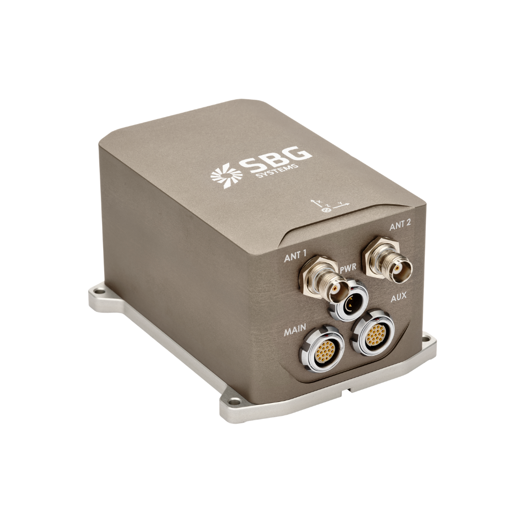
Apogee-D
Apogee-D is an advanced Inertial Navigation System (INS). It features a dual-antenna, triple-frequency GNSS receiver that supports GPS, GLONASS, BEIDOU, and GALILEO constellations.
The system excels across diverse mobile applications. Thanks to the combination of MEMS sensors with GNSS for precise position, orientation, and velocity data in challenging environments.
It proves invaluable in multiple sectors, including autonomous vehicles, battlefield management, mobile mapping, and geospatial surveying. Not to mention, how its resistance to GNSS disruptions makes it particularly suitable for UAVs, aircraft navigation, and maritime operations.
Ask a quotation for Apogee-D
Do you have questions?
Welcome to our FAQ section! Here, you’ll find answers to the most common questions about the applications we showcase. If you don’t find what you’re looking for, feel free to contact us directly!
What is GNSS post-processing?
GNSS post-processing, or PPK, is an approach where the raw GNSS data measurements logged on a GNSS receiver are processed after the data acquisition activity. They can be combined with other sources of GNSS measurements to provide the most complete and accurate kinematic trajectory for that GNSS receiver, even in the most challenging environments.
These other sources can be local GNSS base station at or near the data acquisition project, or existing continuously operating reference stations (CORS) typically offered by governmental agencies and/or commercial CORS network providers.
A Post-Processing Kinematic (PPK) software can make use of freely available GNSS satellite orbit and clock information, to help further improve the accuracy. PPK allow for precise determination of a local GNSS base station’s location in an absolute global coordinate reference frame datum, which is used.
PPK software can also support complex transformations between different coordinate reference frames in support of engineering projects.
In other words, it gives access to corrections, enhances the project’s accuracy, and can even repair data losses or errors during the survey or installation after the mission.
What is bathymetry?
Bathymetry is the study and measurement of the depth and shape of underwater terrain, primarily focused on mapping the seafloor and other submerged landscapes. It is the underwater equivalent of topography, providing detailed insights into the underwater features of oceans, seas, lakes, and rivers. Bathymetry plays a crucial role in various applications, including navigation, marine construction, resource exploration, and environmental studies.
Modern bathymetric techniques rely on sonar systems, such as single-beam and multibeam echo sounders, which use sound waves to measure water depth. These devices send sound pulses toward the seafloor and record the time it takes for the echoes to return, calculating depth based on the speed of sound in water. Multibeam echo sounders, in particular, allow for wide swaths of the seafloor to be mapped at once, providing highly detailed and accurate seafloor representations.
Bathymetric data is essential for creating nautical charts, which help guide vessels safely by identifying potential underwater hazards like submerged rocks, wrecks, and sandbanks. It also plays a vital role in scientific research, helping researchers understand underwater geological features, ocean currents, and marine ecosystems.
What is the difference between RTK and PPK?
Real-Time Kinematic (RTK) is a positioning technique where GNSS corrections are transmitted in near real time, typically using an RTCM format correction stream. However, there can be challenges in ensuring the GNSS corrections, specifically their completeness, availability, coverage, and compatibility.
The major advantage of PPK over RTK post processing is that the data processing activities can be optimized during post-processing, including forward and backward processing, whereas in real-time processing, any interruption or incompatibility in the corrections and their transmission will lead to lower accuracy positioning.
A first key advantage of GNSS post-processing (PPK) vs. real time (RTK) is that the system used on the field does not need to have a datalink/radio to feed the RTCM corrections coming from the CORS into the INS/GNSS system.
The main limitation to post processing adoption is the requirement of the final application to act on the environment. On the other hand, if your application can withstand the additional processing time needed to produce an optimized trajectory, it will greatly improve the data quality for all your deliverables.
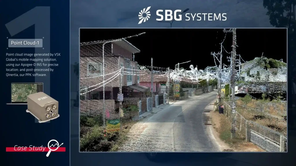
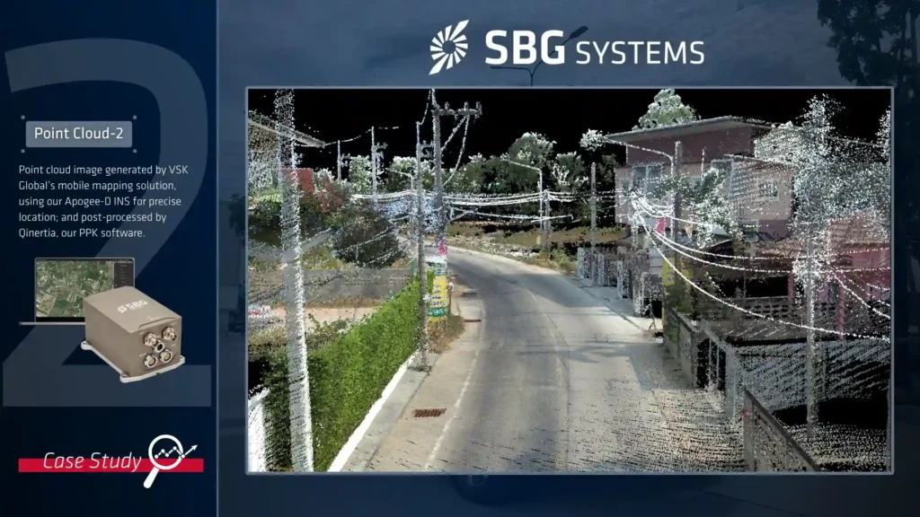
What is a point cloud ?
A point cloud is a collection of data points in three-dimensional space that represents the external surface of objects or environments. Each point contains specific X, Y, and Z coordinates, and can include additional information such as color, intensity, or reflection values.
These datasets, which can contain millions or billions of points, are typically created by 3D scanners or other sensing devices. Point clouds are essential tools in various applications, including 3D modeling and visualization, Building Information Modeling (BIM), autonomous vehicle navigation, and quality inspection and control, making them a fundamental component of modern spatial data collection and analysis.
What is the relation between point cloud data and LiDAR tehnology ?
LiDAR technology and point cloud data are intrinsically connected as LiDAR sensors create point clouds by emitting laser pulses and measuring their return time. Each reflected laser pulse becomes a point in three-dimensional space, with specific X, Y, and Z coordinates.
These sensors can collect millions of points per second, generating highly detailed point cloud datasets that represent the scanned environment. The resulting point clouds are invaluable for various applications, including 3D mapping, terrain analysis, building surveys, and autonomous vehicle navigation systems, making LiDAR one of the primary technologies for generating accurate and detailed point cloud representations of the physical world.
