PPK (Post-Processing Kinematic) is a GNSS data processing method that achieves high-accuracy positioning by correcting errors in raw positioning data. Post-processing is widely used in applications that require precise geospatial information, such as surveying, mapping, and UAV operations.
SBG Systems has developed an in-house GNSS Post-Processing solution to enhance its inertial navigation systems’ performances.
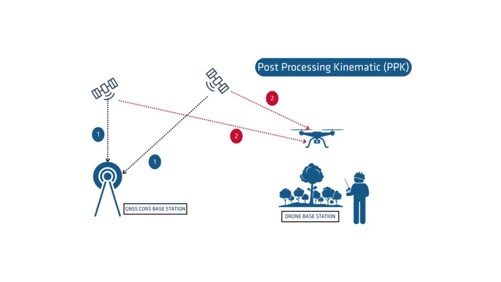
What is GNSS post-processing?
PPK post-processing is an approach where the system processes the raw GNSS data measurements logged on a GNSS receiver after data acquisition. You can combine them with other sources of GNSS measurements to provide the most complete and accurate kinematic trajectory for the GNSS receiver, even in the most challenging environments.
These other sources can be local GNSS base station at or near the data acquisition project, or existing continuously operating reference stations (CORS) typically offered by governmental agencies and/or commercial CORS network providers.
A Post-processing Kinematic (PPK) software can make use of freely available GNSS satellite orbit and clock information, to help further improve the accuracy. PPK allows for the precise determination of a local GNSS base station’s location in an absolute global coordinate reference frame datum, which it uses.
PPK software can also support complex transformations between different coordinate reference frames in support of engineering projects.
In other words, it gives access to corrections, enhances the project’s accuracy, and can even repair data losses or errors during the survey or installation after the mission.
RTK vs PPK
Real-Time Kinematic (RTK) is a positioning technique that transmits GNSS corrections in near real time, typically using an RTCM format correction stream. However, there can be challenges in ensuring the GNSS corrections, specifically their completeness, availability, coverage, and compatibility.
PPK offers the major advantage of optimizing data processing activities during post-processing, including forward and backward processing. In contrast, real-time processing can suffer from interruptions or incompatibilities in corrections and their transmission, leading to lower accuracy positioning.
A first key advantage of GNSS PPK post-processing vs. real time (RTK) is that the system used on the field does not need to have a datalink/radio to feed the RTCM corrections coming from the CORS into the INS/GNSS system.
The main limitation to post processing adoption is the requirement of the final application to act on the environment. On the other hand, if your application can withstand the additional processing time needed to produce an optimized trajectory, it will greatly improve the data quality for all your deliverables.
How does forward and backward processing improves data accuracy?
Let’s imagine we have a 60-second GNSS outage in the middle of our survey. The position error in forward processing grows fast (rate depends on the IMU specifications and other parameters) and reaches its maximum at the end of the outage. It then quickly recovers.
In post processing, we pretend that time flows backward and do the processing in anti-chronological order as the physical equations remains valid. In this backward processing, the error would be maximum at the actual beginning of the GNSS outage in a very symmetrical way to the natural forward processing.
Merging those two computation results in a maximum error around the middle of the outage, with a much lower magnitude than the forward only or backward only solutions.
This will especially improve GNSS+INS solutions as allowed by SBG Systems products, but GNSS only processing will also benefit from this workflow.
As stated earlier, post-processing is the only way to achieve this improvement because you need all the data from start to finish, which delays its use until the end of the survey.
Accessible to all surveying applications
RTK is widely used for high-accuracy GNSS positioning in mapping, construction control, and marine applications requiring real-time results. Post-processing of INS data benefits UAV and USV applications where radio implementation and RTCM correction stream monitoring are challenging.
Airborne surveyors tend to use PPK, because datalinks to airplanes are difficult to do, as cellular network work badly in altitude because of the ground broadcasting antennas orientation.
Other applications needing Post processing Kinematic are those where data (image or LiDAR data, for example) are processed in a subsequent workflow, often in the cloud, and where the processing of the trajectory with a GNSS post processing software like Qinertia can easily be added.
