
The Earth-Centered, Earth-Fixed (ECEF) frame is a global coordinate system used to represent positions on or near Earth. It is a rotating reference frame that remains fixed relative to Earth’s surface, meaning it moves with the planet as it rotates. Engineers, scientists, and navigation systems use ECEF coordinates to track positions accurately in a global context.
ECEF Coordinate System
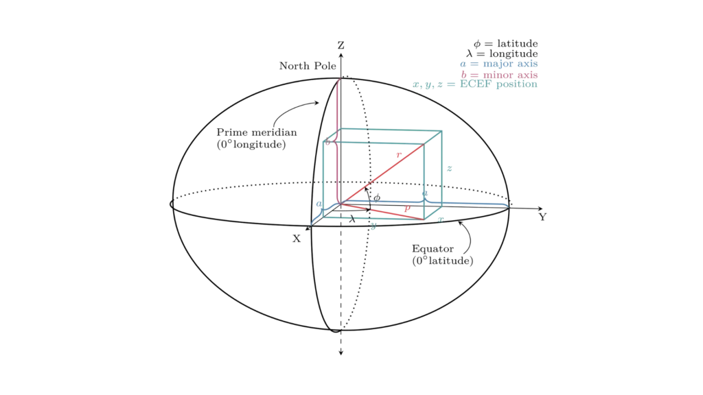
An Earth-centered Earth-fixed (ECEF) system represents position relative to the center of the reference ellipsoid using Cartesian coordinates (X, Y, Z). The reference ellipsoid determines the distance between its center and the Earth’s center.
ECEF defines locations using these three axes centered at Earth’s core:
1 – The positive X-axis intersects the ellipsoid’s surface at 0° latitude and 0° longitude, where the equator meets the prime meridian.
2 – The positive Y-axis intersects the ellipsoid’s surface at 0° latitude and 90° longitude.
3 – The positive Z-axis intersects the ellipsoid’s surface at 90° latitude and 0° longitude, the North Pole.
Examples of ECEF Applications
Firstly, GPS satellites broadcast signals in ECEF coordinates. Next, a smartphone receives signals from multiple satellites and calculates its position in the Earth-Centered, Earth-Fixed Frame before converting it to latitude, longitude, and altitude.
Similarly, flight management systems use ECEF coordinates to determine an aircraft’s position. As a result, they enable accurate global tracking, even over oceans or remote regions.
Meanwhile, satellites orbit Earth in an inertial frame but use the ECEF frame to communicate their positions. Consequently, ground stations track them in this reference system to ensure precise orbital adjustments.
Likewise, surveyors rely on ECEF coordinates to map large-scale infrastructure projects. By doing so, they reference a stable Earth-centered system and minimize measurement errors across continents.
Finally, engineers use ECEF coordinates to plan missile and rocket launches, ensuring precise targeting and orbital insertion. This way, they accurately calculate how Earth’s rotation affects a vehicle’s path. This version maintains clarity while improving flow and engagement. Let me know if you’d like any tweaks!
ECEF simplifies global positioning by aligning with Earth’s surface, making it essential for GPS, aerospace, and geodetic applications
Tell us about your project