Wave measurement in the arctic sea
Open Ocean and In-ice Waves Measurement with AHRS.
“Units were reliable, with no failures in the harsh Arctic conditions. They have been running continuously for over a year without requiring power cycling etc.” | Dr. Martin Doble
Marginal Ice Zone (MIZ) Program
Over recent decades the Arctic has warmed more than any other region leading to significant reduction in sea ice volume. The combination of increased ice-free area and more mobile ice cover has led to the emergence of a seasonal marginal ice zone (MIZ) in the Beaufort Sea.
The Office of Naval Research MIZ initiative engages an integrated program of observations and simulations to investigate the ice-ocean-atmosphere dynamics with several autonomous systems including wave buoys.
Ellipse-A to study the ocean waves characteristics
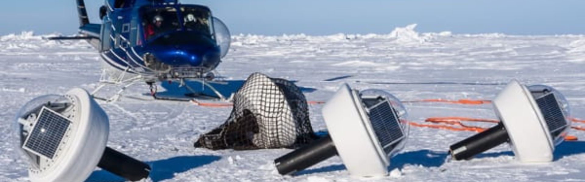
The program included 25 Wave Buoys to quantify high seas and in-ice wave characteristics and evolution. Twenty buoys were deployed in the summer period, 5 in the winter. “We needed a very rapid and cost-effective solution to measuring directional wave spectra in the ocean.
Time to deployment was short, so an integrated solution, giving us good heave numbers straight out of the box, was essential. Delivery time of the units was also critical”, indicates Dr. Martin Doble, oceanographer at the French UPMC School and member of the oceoresearch program.
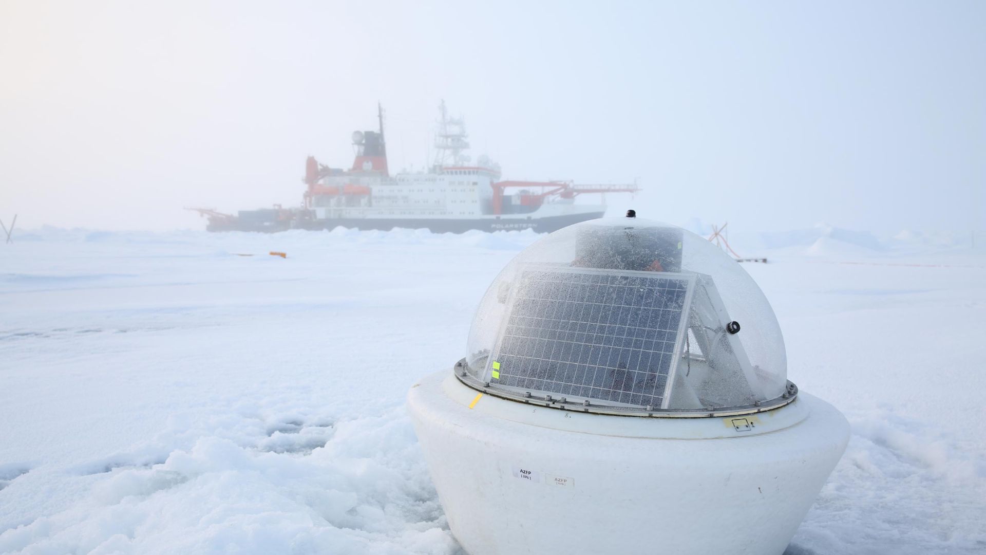
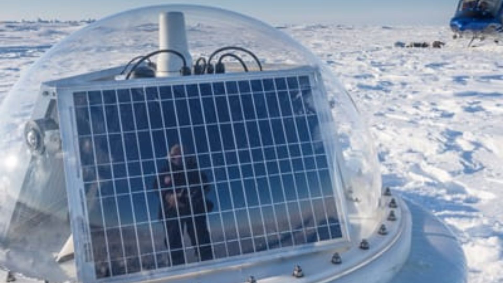
The summer buoys, firstly drilled into the ice, were powered with solar panels, and equipped with Ellipse-A inertial motion sensors to detect both distant and near wave effects on the local ice floe. Once the ice melted, the summer buoys continued to measure open ocean characteristics.
The 5 winter buoys were installed on the ice. These buoys were made of aluminium for better resistance and contained enough batteries to power them through the dark winter months. Every buoy also contained processing and control electronics, an SD card, a GPS, and an Iridium satellite modem and antennas to transmit the recorded data on demand to the Cambridge base station.
Summer buoys (open ocean waves) and winter buoys (in-ice waves) data were also used together to quantify the wave attenuation rate.
When temperature calibration makes sense
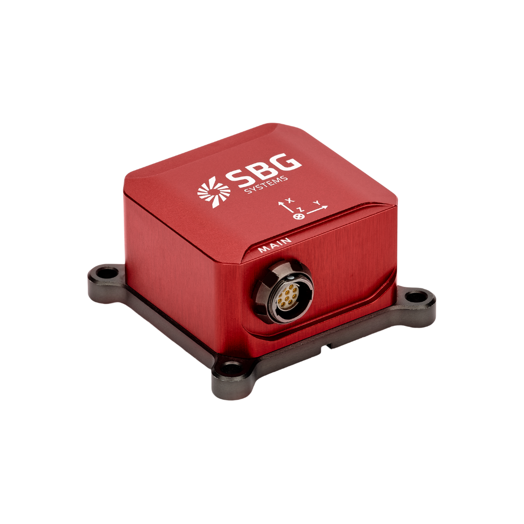
The Ellipse-A inertial sensors were used here for wave height and direction. Ellipse-A measures in real-time roll, pitch, heading accurate to 0.35°, and heave, accurate to 10 cm.
Every sensor is calibrated for bias, linearity, gain, misalignment, cross-axis and gyro-g from -40°C to +85°C. It allows them to provide reliable data in harsh environment, and what can be harsher than the Arctic ice ? “Units were reliable, with no failures in the harsh Arctic conditions.
The Ellipse-A have been running continuously for over a year without requiring power cycling etc., and the numbers look good, giving clear results,” to quote Dr. Doble.
“We needed a very rapid and cost-effective solution to measuring directional wave spectra in the ocean.” | Dr. Martin Doble
Ellipse-A: High Performance Miniature AHRS
During the project, the Ellipse Series was released, a new line replacing the IG-500 series.
More accurate in attitude and more reliable (IP68) for the same budget, the new miniature inertial sensors now provide a heave that automatically adjusts to the wave period for higher performance.
The Ellipse-A sensors are currently used in a new ONR project in the Beaufort/ Chukchi Seas.
Ellipse-A
Ellipse-A is an affordable and high-performance Attitude and Heading Reference System (AHRS). It embeds a best-in-class magnetic calibration procedure for optimal heading, and is suitable for low to medium dynamic applications.
Factory calibrated from -40°C to 85°C, this robust inertial motion sensor provides Roll, Pitch, Heading, and Heave data.
Ask a quotation for Ellipse-A
Do you have questions?
Welcome to our FAQ section! Here, you’ll find answers to the most common questions about the applications we showcase. If you don’t find what you’re looking for, feel free to contact us directly!
What are wave measurement sensors?
Wave measurement sensors are essential tools for understanding ocean dynamics and improving safety and efficiency in marine operations. By providing accurate and timely data on wave conditions, they help inform decisions across various sectors, from shipping and navigation to environmental conservation.
Wave buoys are floating devices equipped with sensors to measure wave parameters such as height, period, and direction.
They typically use accelerometers or gyroscopes to detect wave motion and can transmit real-time data to shore-based facilities for analysis.
What is bathymetry?
Bathymetry is the study and measurement of the depth and shape of underwater terrain, primarily focused on mapping the seafloor and other submerged landscapes. It is the underwater equivalent of topography, providing detailed insights into the underwater features of oceans, seas, lakes, and rivers. Bathymetry plays a crucial role in various applications, including navigation, marine construction, resource exploration, and environmental studies.
Modern bathymetric techniques rely on sonar systems, such as single-beam and multibeam echo sounders, which use sound waves to measure water depth. These devices send sound pulses toward the seafloor and record the time it takes for the echoes to return, calculating depth based on the speed of sound in water. Multibeam echo sounders, in particular, allow for wide swaths of the seafloor to be mapped at once, providing highly detailed and accurate seafloor representations.
Bathymetric data is essential for creating nautical charts, which help guide vessels safely by identifying potential underwater hazards like submerged rocks, wrecks, and sandbanks. It also plays a vital role in scientific research, helping researchers understand underwater geological features, ocean currents, and marine ecosystems.
What is a buoy used for?
A buoy is a floating device primarily used in maritime and water-based environments for several key purposes. Buoys are often placed in specific locations to mark safe passages, channels, or hazardous areas in bodies of water. They guide ships and vessels, helping them avoid dangerous spots like rocks, shallow waters, or wrecks.
They are used as anchoring points for vessels. Mooring buoys allow boats to tie up without having to drop anchor, which can be especially useful in areas where anchoring is impractical or damaging to the environment.
Instrumented buoys are equipped with sensors to measure environmental conditions like temperature, wave height, wind speed, and atmospheric pressure. These buoys provide valuable data for weather forecasting, climate research, and oceanographic studies.
Some buoys act as platforms for collecting and transmitting real-time data from the water or seabed, often used in scientific research, environmental monitoring, and military applications.
In commercial fishing, buoys mark the location of traps or nets. They also help in aquaculture, marking the locations of underwater farms.
Buoys can also mark designated areas such as no-anchoring zones, no-fishing zones, or swimming areas, helping enforce regulations on the water.
In all cases, buoys are critical for ensuring safety, facilitating marine activities, and supporting scientific research.
What is buoyancy?
Buoyancy is the force exerted by a fluid (such as water or air) that opposes the weight of an object submerged in it. It allows objects to float or rise to the surface if their density is less than that of the fluid. Buoyancy occurs because of the difference in pressure exerted on the object’s submerged portions—greater pressure is applied at lower depths, creating an upward force.
The principle of buoyancy is described by Archimedes’ principle, which states that the upward buoyant force on an object is equal to the weight of the fluid displaced by the object. If the buoyant force is greater than the object’s weight, it will float; if it is less, the object will sink. Buoyancy is essential in many fields, from marine engineering (designing ships and submarines) to the functionality of floating devices like buoys.
