Ellipse embedded in airborne hyperspectral imaging systems
Ellipse chosen by Resonon for its low SWAP-C, high performance, and affordable price.
“SBG Inertial Navigation units are a perfect complement to Resonon’s airborne hyperspectral imaging systems, enabling the use of smaller and smaller drones. SBG’s technology and support make them a trusted partner for today’s high-performance navigational systems.” | Casey Smith, Resonon Chief Technology Officer

Resonon designs, manufactures, and deploys hyperspectral imaging systems. Their cameras are used worldwide for research and in industry by multiple Fortune 500 companies.
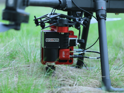
They integrate our Ellipse INS (Ellipse-N and Ellipse-D) into their airborne hyperspectral imaging systems, which are complete solutions containing all the hardware and software necessary to acquire georegistered hyperspectral data.
These systems can be mounted on both drones and piloted aerial platforms. The Ellipse INS data is used to directly georeference the imaging data. Lets’ dive in into this case study of a great partnership allowing a great precision and high-performance results.
Low SWAP-C and high performance with Ellipse
Resonon needed a small and lightweight GPS/IMU solution, offering high precision and resolution, with a good SDK and USB interface. To reinforce their competitive position of “high performance, low SWaP, and high value” within their hyperspectral product line, Resonon wanted an INS that complemented these advantages.
They integrated and evaluated 5 systems from different vendors but found that Ellipse represents the best value for its precision, SWaP, and cost. Resonon engineers particularly like the SDK and ease of use.
Ellipse INS tight integration and cooperation
Ellipse is mounted with Resonon’s hyperspectral imager in a strap-down direct georeferencing modality and connected to their data acquisition system via its USB output.
This system collects hyperspectral data synchronously with the attitude and location data from the Ellipse INS, which are then used to georectify the hyperspectral data in post-processing.
Inertial navigation systems are sophisticated devices, as are hyperspectral imagers! Our support team has always been timely and helpful, both during the integration phase as Resonon’s navigated the SDK, but also in helping them assist their end customers to solve their application and installation specific needs.
Most recently, the company added support for an RTK base station for customers who need very precise geolocation, and our SBG team assisted them in this development.
About hyperspectral imaging
Hyperspectral imaging is an advanced technique that enables the acquisition of detailed and comprehensive information about objects or scenes beyond what traditional imaging methods can provide. It involves the acquisition of data across a wide range of wavelengths, including both the visible and non-visible portions of the electromagnetic spectrum.
Unlike conventional imaging systems that capture only a few discrete spectral bands, hyperspectral imaging collects hundreds of narrow and contiguous spectral bands, resulting in a highly detailed spectral signature for each pixel in an image.
The rich spectral information provided by hyperspectral imaging allows for enhanced characterization, analysis, and discrimination of materials and substances. Applications include remote sensing, agriculture crop surveillance, environmental monitoring, geology mapping, and medical diagnostics.
By analyzing the unique spectral properties of different materials, hyperspectral imaging can identify and differentiate objects based on their chemical composition, moisture content, temperature, or other physical characteristics.
This technology has proven particularly valuable in tasks such as vegetation analysis, mineral exploration, disease detection, and surveillance, where precise identification and discrimination of objects or substances is crucial for accurate decision-making and analysis.
With ongoing advancements in sensor technology and data processing algorithms, hyperspectral imaging continues to evolve as a powerful tool for extracting valuable insights from complex data sets and pushing the boundaries of imaging capabilities.


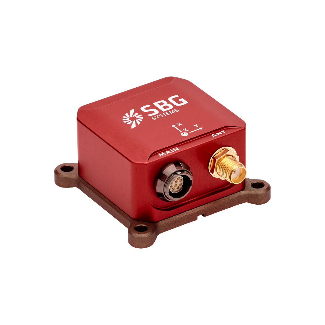
Ellipse-N
Ellipse-N is a compact and high-performance RTK Inertial Navigation System (INS) with an integrated Dual band, Quad Constellations GNSS receiver. It provides roll, pitch, heading, and heave, as well as a centimetric GNSS position.
Ellipse-N sensor is best suited for dynamic environments, and harsh GNSS conditions, but can also operate in lower dynamic applications with a magnetic heading.
Ask a quotation for Ellipse-N
Do you have questions?
Welcome to our FAQ section! Here, you’ll find answers to the most frequent questions about the applications we highlight. If you don’t find what you’re looking for, feel free to contact us directly!
Do UAVs use GPS?
Unmanned Aerial Vehicles (UAVs), commonly known as drones, typically use Global Positioning System (GPS) technology for navigation and positioning.
GPS is an essential component of a UAV’s navigation system, providing real-time location data that enables the drone to determine its position accurately and execute various tasks.
In recently years, this term has been replaced by a new term GNSS (Global Navigation Satellite System). GNSS refers to the general category of satellite navigation systems, which encompasses GPS and various other systems. In contrast, GPS is a specific type of GNSS developed by the United States.
What is GNSS post-processing?
GNSS post-processing, or PPK, is an approach where the raw GNSS data measurements logged on a GNSS receiver are processed after the data acquisition activity. They can be combined with other sources of GNSS measurements to provide the most complete and accurate kinematic trajectory for that GNSS receiver, even in the most challenging environments.
These other sources can be local GNSS base station at or near the data acquisition project, or existing continuously operating reference stations (CORS) typically offered by governmental agencies and/or commercial CORS network providers.
A Post-Processing Kinematic (PPK) software can make use of freely available GNSS satellite orbit and clock information, to help further improve the accuracy. PPK allow for precise determination of a local GNSS base station’s location in an absolute global coordinate reference frame datum, which is used.
PPK software can also support complex transformations between different coordinate reference frames in support of engineering projects.
In other words, it gives access to corrections, enhances the project’s accuracy, and can even repair data losses or errors during the survey or installation after the mission.
