Ellipse compatible with Cobham satcom
Compatibility between Ellipse-D and Aviator UAV 200 is stated by the CNES for Antenna Pointing. “SBG’s Ellipse-D INS has a remarkable compact design which will enable UAV industrials improve and develop the services they offer; this is the French know-how at the forefront of the innovation.” – CNES’ Cesars center team

The CNES, also called the National Center for Space Studies, is a French agency dedicated to space studies. They operate under the supervision of both the Ministries of Economy, Defense and Research.
CNES’s CESARS Center Makes Access to Satellite Communication Easier
One mission is to develop, present, and execute the French Spatial Program for the national government. The CNES focuses on 5 strategic areas: Ariane (Launchers), Sciences, Observation, Telecommunications, and Defense.
The CNES created the center CESARS in order to spread and increase the usage of Satcom in any new kind of application.
CESARS welcomes freely companies, laboratories, collectivities, to give them advice, feedback on technologies, assist them by performing tests, and giving access to the technical platform in itself, including the hardware.
A combined solution for enhanced real-time control for UAV navigation
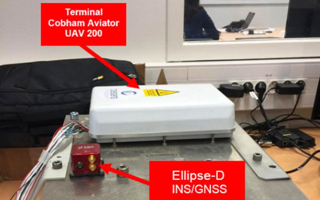
The CESARS team usually tests and verifies equipment on the ground before proceeding with a project. Here, the goal was to confirm the compatibility between Cobham’s AVIATOR UAV 200 and SBG Systems’ Ellipse-D Inertial Navigation System.
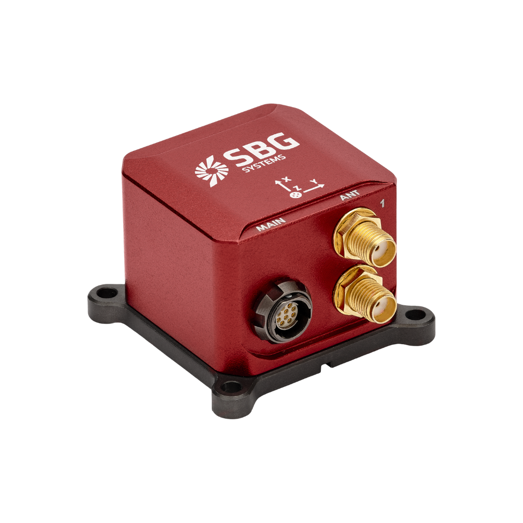
Ellipse-D is a miniature dual-antenna Inertial Navigation Systems that provides highly accurate navigation and orientation data even in the most challenging environments.
Like all SBG’s sensors, Ellipse-D INS/GNSS is extensively tested and calibrated from -40°C to 85°C to ensure optimal performance.
The AVIATOR UAV 200 is a compact all-in-one Satcom terminal (antenna and modem) that fits in a small UAV. It allows the connection between a UAV and a satellite, which acts as an intermediary between the UAV and the ground control.
Cobham’s solution transmits information, like videos, from the UAV to ground control at a very low data rate (200kbps). The AVIATOR UAV 200 enables the UAV to fly longer and further away from the control room via BLOS (Beyond Line of Sight) communication.
How do they work together?
The inertial sensor sends roll, pitch, yaw, heading, and position inputs to the AVIATOR UAV 200. We use these data to steer the AVIATOR UAV 200’s antenna beam towards a telecommunication satellite and track it precisely.
Afterwards, this contributes to maintain an optimal data transmission. The more accurate the antenna pointing is, the more stable the satellite link will be.
Ellipse-D INS/GNSS provides precise, reliable heading at start time, thanks to its dual antenna GNSS receiver, critical for these applications. The INS sensor provides motion and position data to help the AVIATOR UAV 200 maintain the satellite link during flight.
In case of spoofing, the INS will help maintaining a robust heading thanks to the Extended Kalman Filter.
Stationary and on the move tests in ground configuration
In October 2020, the CNES conducted a few tests within the CST (Toulouse Space Center).
First, the hardware and software were taken in hand in the laboratory. The hardware was then integrated into the Oscar truck (OSCAR is a “mobile laboratory” on which OTM antennas are set and tested, on the roads).
After checking that it was working properly in stationary mode, OTM tests inside the CNES were run to attest the compatibility between the inertial sensor and the terminal.
Configuration of the equipment
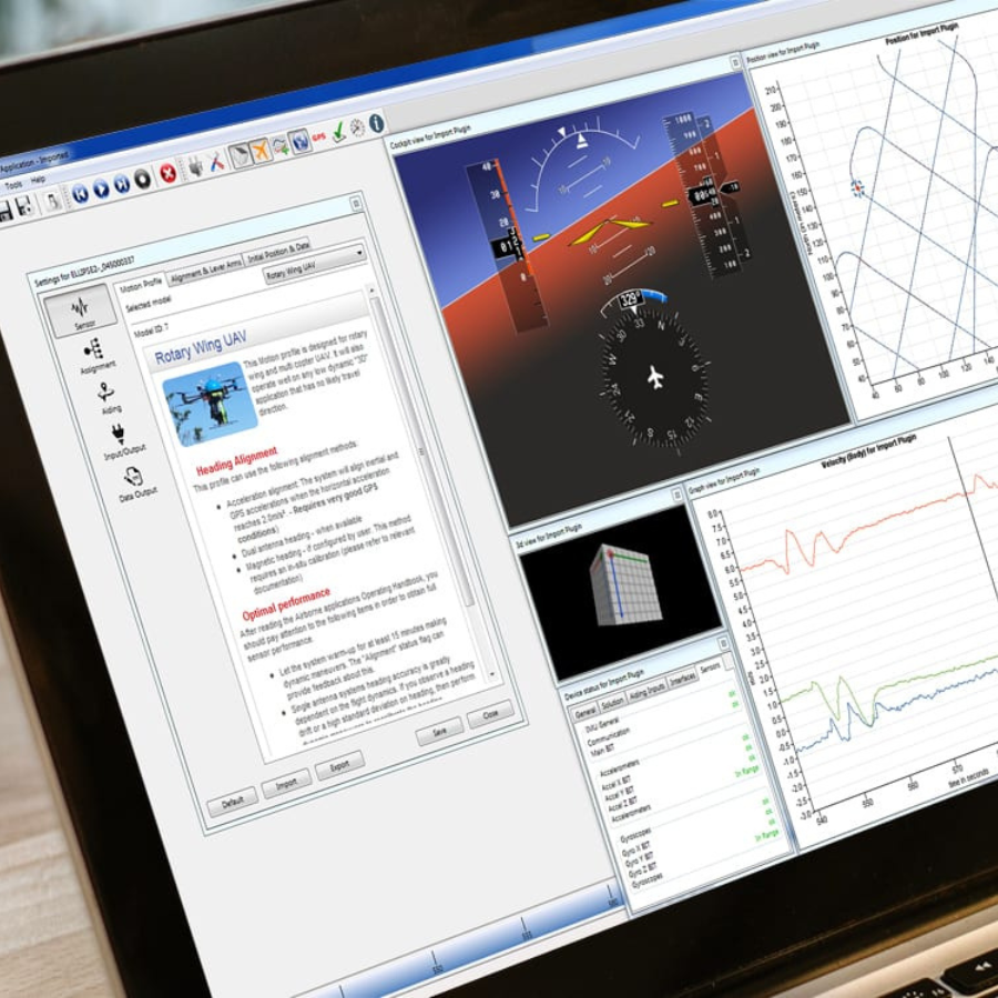
During the test in stationary mode in the laboratory, the CNES used the sbgcenter software that comes with the Ellipse-D INS/GNSS to configure the equipment to best fit their application.
This software provides different motion profiles to adjust the Extended Kalman Filter parameter and deliver the best performance for the conditions of use.
Chosen settings on sbgCenter software:
- Profile choice: “general purpose”. It was the most suitable for the behavior of the Oscar truck. For an integration on a UAV, a UAV profile must be chosen.
- Configuration of the 2 GNSS antennas: must be at more than 45 cm from the Cobham terminal, and in a similar “environment” (close enough, no obstacles between them, must undergo the same dynamics).
- Alignment of the vehicle in relation to the control unit entered (in our case they are oriented along the same axis).
- If other sensors are placed on the carrier, they can be entered too (pitot tube, accelerometer…).
- The com port A of the Ellipse-D INS/GNSS (the “main”) is connected to the PC to visualize the information received on the sbgcenter. Port E is connected to the Cobham terminal. Both are configured at 115200 bauds.
- As far as the data output is concerned, the transmission frequency of the AT_ITINS messages must be at 50Hz maximum.

Integration and OTM Test
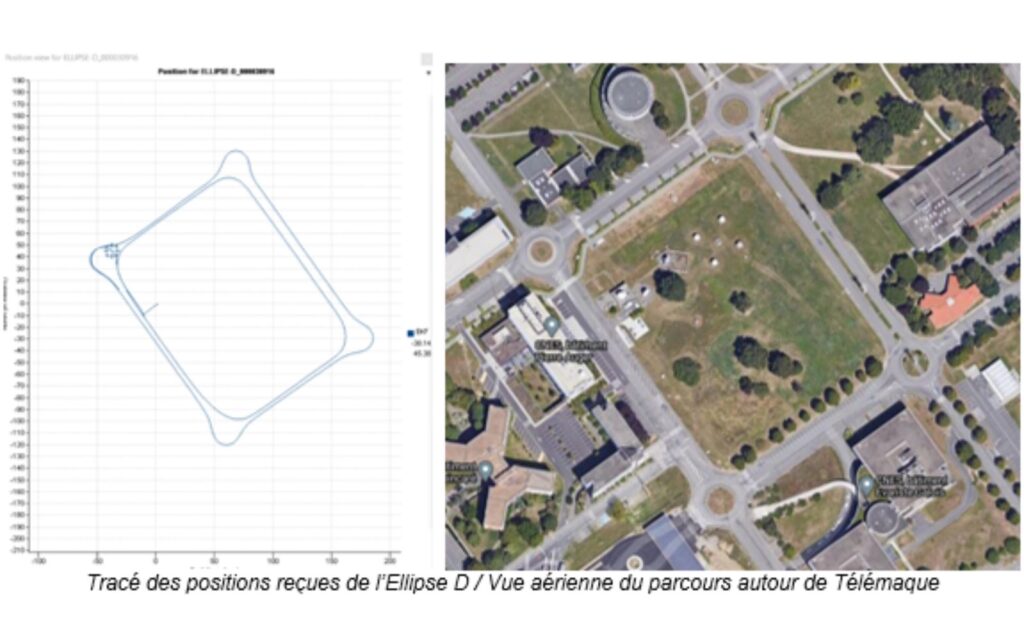
Two “On-The-Move” tests were conducted on the same circuit. The test circuit includes straight lines and traffic circles and the maximum speed to complete it was 30km/H
The first test revealed that settings adjustments were necessary, especially the transmission frequency which was set too high. During the second test the connection was stable, even when changing direction, validating the settings.
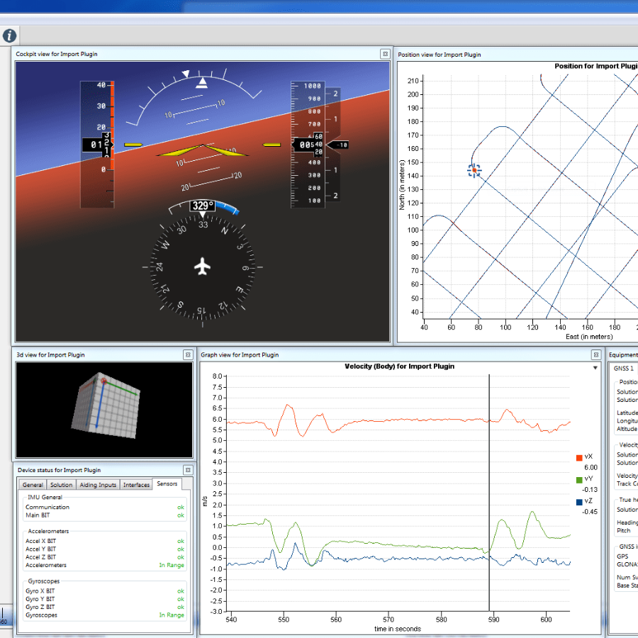
The ping passed correctly, and the longest latencies observed are those following a passage near a building (possible masking of the LOS). On the Aviator UAV 200 interface, everything worked (signal level >50dbHz, GPS fix). By recording the test sessions, the sequences can be replayed on the SBGcenter through different options:
- Position view: It shows a figure with animations where you can follow the vehicle’s path.
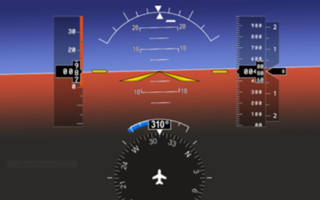
- Cockpit View: A graphical user interface with visualization of the carrier’s attitude data.
Conclusion
After all those tests, CNES’ Cesars center team came to the conclusion that SBG Systems’ Ellipse-D Inertial Navigation System is compatible with Cobham Aviator UAV 200 terminal, in a “ground” configuration.
This conclusive test brings a wide panel of opportunities to UAV users.
Ellipse-D
The Ellipse-D is an inertial navigation system integrating a dual antenna and dual frequency RTK GNSS that is compatible with our Post-Processing software Qinertia.
Designed for robotic and geospatial applications, it can fuse Odometer input with Pulse or CAN OBDII for enhanced dead-reckoning accuracy.
Ask a quotation for Ellipse-D
Do you have questions?
Welcome to our FAQ section! Here, you’ll find answers to the most common questions about the applications we showcase. If you don’t find what you’re looking for, feel free to contact us directly!
Do UAVs use GPS?
Unmanned Aerial Vehicles (UAVs), commonly known as drones, typically use Global Positioning System (GPS) technology for navigation and positioning.
GPS is an essential component of a UAV’s navigation system, providing real-time location data that enables the drone to determine its position accurately and execute various tasks.
In recently years, this term has been replaced by a new term GNSS (Global Navigation Satellite System). GNSS refers to the general category of satellite navigation systems, which encompasses GPS and various other systems. In contrast, GPS is a specific type of GNSS developed by the United States.
How to control output delays in UAV operations?
Controlling output delays in UAV operations is essential for ensuring responsive performance, precise navigation, and effective communication, especially in defense or mission-critical applications.
The output latency is an important aspect in real time control applications, where a higher output latency could degrade control loops performance. Our INS embedded software has been designed to minimize output latency: once sensor data are sampled, the Extended Kalman Filter (EKF) performs small and constant-time computations before the outputs are generated. Typically the observed output delay is less than one millisecond.
The processing latency should be added to the data transmission latency if you want to get total delay. This transmission latency vary from one interface to another. For instance, a 50 bytes message sent on a UART interface at 115200 bps will take 4ms for complete transmission. Consider higher baudrates to minimize output latency.
What is UAV geofencing?
UAV geofencing is a virtual barrier that defines specific geographic boundaries within which an unmanned aerial vehicle (UAV) can operate.
This technology plays a critical role in enhancing the safety, security, and compliance of drone operations, particularly in areas where flight activities may pose risks to people, property, or restricted airspace.
In industries like delivery services, construction, and agriculture, geofencing helps ensure that drones operate within safe and legal areas, avoiding potential conflicts and enhancing operational efficiency.
Law enforcement and emergency services can use geofencing to manage UAV operations during public events or emergencies, ensuring drones do not enter sensitive areas.
Geofencing can be employed to protect wildlife and natural resources by restricting drone access to certain habitats or conservation areas.
What is a payload?
A payload refers to any equipment, device, or material that a vehicle (drone, vessel …) carries to perform its intended purpose beyond the basic functions. The payload is separate from the components required for the vehicle operation, such as its motors, battery, and frame.
Examples of Payloads:
- Cameras: high-resolution cameras, thermal imaging cameras…
- Sensors: LiDAR, hyperspectral sensors, chemical sensors…
- Communication equipment: radios, signal repeaters…
- Scientific instruments: weather sensors, air samplers…
- Other specialized equipment
