QINERTIA
Precision Made Simple
Welcome to the forefront of geospatial innovation. Qinertia PPK software offers an all-new level in high-precision positioning solutions. In a world that demands accuracy without compromise, our software is emerging as the cornerstone for professionals and industries seeking unparalleled confidence in their location data.
Pushing the boundaries with Qinertia
Designed to complement your inertial navigation systems (INS), Qinertia offers powerful post-processing capabilities that transform raw GNSS and IMU data into highly accurate positioning and orientation solutions.
With an intuitive interface and compatibility with multiple datasets, users can easily process data, refine trajectories, and gain actionable insights for demanding applications, including UAV mapping, mobile mapping, and marine surveying.
New Geodesy Engine
The new Geodesy Engine in Qinertia boasts an exhaustive suite of tools that are not only incredibly user-friendly but also highly versatile.
With an extensive selection of preconfigured Coordinate Reference Systems (CRS), Qinertia let you harness the essential official systems and transformations for your projects. You can also craft custom transformations tailored to your specific or scientific requirements.
IonoShield mode
The IonoShield mode in Qinertia revolutionizes how you manage ionospheric activity in your logs. Monitoring ionospheric conditions has never been easier.
Now, you can effortlessly assess the ionospheric activity and baseline length, enabling you to make informed decisions about the optimal processing mode for your data.
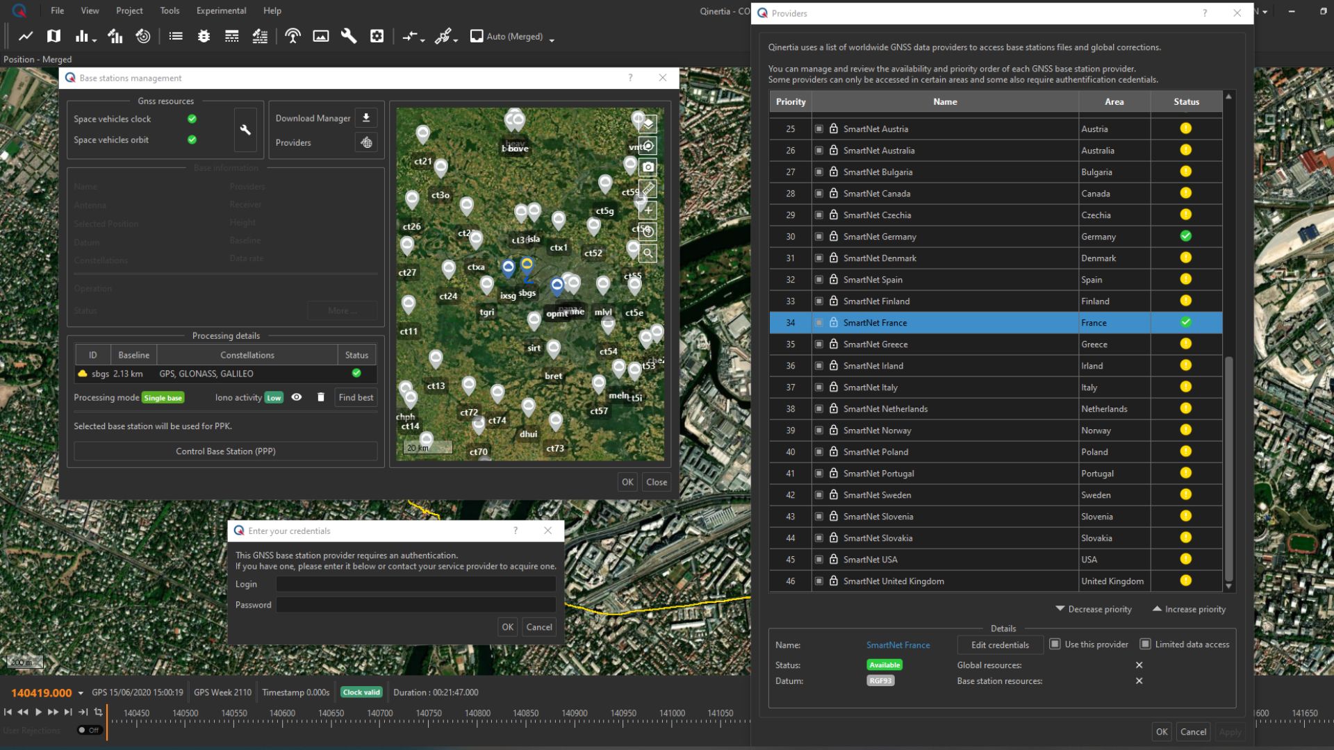
Extended CORS integration
You can now access the SmartNet CORS network, with its impressive 5300 base station worldwide coverage. (additional subscription required).
Smartnet access is seamlessly integrated into Qinertia, ensuring you have the flexibility and convenience to leverage this technology in the way that suits you best.
PPK with live RTCM
You can now achieve unparalleled accuracy in your PPK workflows by processing your data with RTCM corrections that are used in real-time operations. It's important to note that this feature is specifically designed for real-time single-base scenarios and is incompatible with VBS setups.
RTCM Stream in Qinertia redefines precision and provides more options for your PPK.

More Functionalities of Qinertia PPK Software
Experience a transformative approach to GNSS data processing with Qinertia PPK Software by SBG Systems—its powerful functionalities are specifically crafted to elevate your operations to new heights!
Advanced GNSS Display & Settings
Qinertia automatically enhances your PPK accuracy by intelligently excluding satellites with poor signal quality, ensuring that only the highest-quality data is utilized in your computations. What's more, users now have the flexibility to take matters into their own hands by manually disabling individual satellites, entire signal bands, or even entire constellations within their PPK solutions.
To support these advanced capabilities, we've introduced a range of informative graphs that allow you to easily assess GNSS signal quality. Empower yourself with total control and confidence in your GNSS data with the Advanced GNSS Setting & Display in Qinertia.
Tightly Coupled PPP
The tight coupling PPP in Qinertia is now available just 24 hours after your mission. Integrating SBG PPP algorithm with tight coupling brings the accuracy of calculation to a new level.
It not only enhances your real time capability but also significantly improves the post mission data analysis.

Pedestrian Single Antenna Mode
A game-changing feature designed to enhance your experience in low-dynamic scenarios and single-antenna use cases.
Under the Pedestrian motion profile, Qinertia effortlessly aligns your heading, ensuring optimal accuracy even in situations with low dynamic and unlocks a world of possibilities for backpack mapping. Pedestrian alignment, a new solution you've been waiting for.
PPK Made Easy
Pedestrian single antenna mode
- Up to 10,000 base stations in 164 countries directly available in Qinertia
-
Import your own base station and check its position integrity with PPP

Post-processing that always works
- Single Base Station short baseline
- Single base Station Ionoshield mode
- Virtual Base Station for corridor mapping
- Tightly coupled PPP anywhere in the world

User focused software
Modern and user-friendly interface to get you up and running in minutes
- Powerful tools for the most advanced users
- Regularly updated with new features based on user feedback

Integrate Qinertia to your workflow
For Software developers. Use Qinertia Cloud APIs or Qinertia CLI to unleash the power of PPK into your Software:
- User friendly graphical interface
- CLI for recurrent data processing
- Fully customizable outputs & generated reports
Compatible with numerous third party receivers
Qinertia is compatible with third party receivers that can provide raw GNSS data*, including:
Septentrio GNSS receivers
High-performance GNSS receivers known for their robust multi-frequency, multi-constellation support and advanced interference mitigation. Widely used in precision positioning, surveying, and industrial applications.Trimble GNSS receivers
Reliable and versatile receivers that offer high-accuracy GNSS positioning solutions. Used across various industries including construction, agriculture, and geospatial surveying.Novatel GNSS receivers
Advanced GNSS receivers offering precise positioning and high accuracy through multi-frequency and multi-constellation support. Popular in autonomous systems, defense, and surveying applications.Ublox GNSS receivers
Compact, low-power receivers ideal for cost-effective and high-performance GNSS solutions in IoT, automotive, and consumer electronics. They support multiple GNSS constellations for reliable positioning.Standard RINEX files
Receiver Independent Exchange Format (RINEX) files store raw GNSS data, enabling post-processing and compatibility across various GNSS systems, regardless of the receiver used. Commonly used for data sharing and GNSS corrections in geospatial applications.*supported GNSS receivers: dual band and above (L1, L1+L2, L1+L5, L1+L2+L5).
Get access to all Qinertia features:
✓ Parsing of the file formats of the GNSS receiver
✓ GNSS PPK, optionally with inertial coupling
✓ GNSS PPP, optionally with inertial coupling
✓ All display of graphs and analytics
✓ PPK performed using all constellations band available
and much more...
Choose Your Edition
Choose the perfect edition of Qinertia PPK software to match your project needs. Whether you're working on a large-scale infrastructure survey, high-precision mapping, or any project requiring accurate GNSS post-processing, Qinertia offers flexible options.
Each edition provides you with powerful features to process your raw GNSS data and achieve centimeter-level accuracy in just a few clicks.

UAV-based Surveying
Cost-effective solution designed for UAV-based surveying and photogrammetry applications.

Compatible with all third party receivers
Data post-processing from any GNSS receiver (through RINEX) and with binary files from Novatel, Septentrio, Trimble and Ublox.

Cost-effective data post-processing solution
Cost-effective solution offered with the SBG Ellipse miniature inertial sensors.

All-in-one PPK Software
Fully-featured data post-processing for all SBG sensors, in all applications and environments.
Build Your Own Tailored Solution
Qinertia is the next-generation INS/GNSS post-processing software built for all users, whether you're in the mapping industry, engaged in R&D for autonomy systems, working as a marine surveyor nearshore, or looking for customizable post-processing services.
Pre-configured application processing profiles automatically adjust settings based on your application's inertial characteristics.
For seamless integration, incorporate Qinertia into your workflow—whether through its user-friendly interface, powerful CLI for recurrent data processing, or customizable outputs and reports.
You are a software editor or a surveying equipment integrator? Qinertia has been designed for you ! Developers can also leverage Qinertia Cloud APIs to harness the full potential of PPK in their software. Choose between all available solutions and make it your own : Desktop, OEM, Cloud et CLI.
©SBG Systems 2024. All rights reserved